


You may also like
-
Gazetteer of the British Isles Poster
John Bartholomew · 1887 · Detailed British Isles vintage print balancing crisp labels with an atlas-like cartographic layout
Poster from €9 · Framed from €16
Regular price From €6,00Regular price -
Ancient map of London Poster
Friedrich Arnold Brockhaus · 1899 · Detailed London map poster tracing the Thames and street grid in muted tones
Poster from €9 · Framed from €16
Regular price From €6,00Regular price -
Map of Iceland Poster
Kongelige Danske Søkort-Arkiv · 1871 · Detailed nautical vintage print mapping Iceland with soundings and coastal place names
Poster from €9 · Framed from €16
Regular price From €6,00Regular price -
Ancient map of Spain Poster
Carl Diercke · 1905 · Detailed Iberian Peninsula vintage print with regional borders and coastal waters in soft beige and blue
Poster from €9 · Framed from €16
Regular price From €6,00Regular price


-

"Very nice Posters. The quality is amazing and we received it very quickly !"
-

"A shop to visit absolutely. Huge selection of posters. We spent more than an hour there !"
-

"Perfect to find gift. Price are very good. An they can frame and pack it on site"


About the Artist
Atlas of the World refers to the collaborative tradition of atlas production at the turn of the twentieth century, rather than a single artist. These atlases brought together cartographers, engravers, and editors to create comprehensive reference works for schools, libraries, and homes. Around 1900, maps like this were valued for their ability to make geography accessible and visually engaging, reflecting a time when understanding the world was seen as essential knowledge.
Such vintage map posters embody the era’s dedication to accuracy and clarity, serving as both practical tools and objects of quiet prestige on the wall.
The Artwork
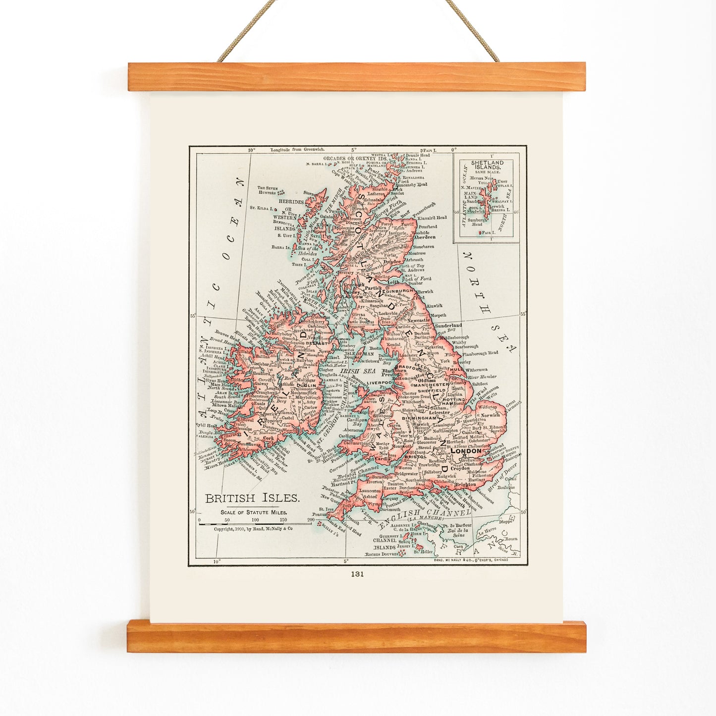
This 1900 map of the British Isles was created during a period when cartography played a crucial role in shaping public perceptions of distance, borders, and national identity. In the Edwardian era, maps like this were indispensable for education and travel, helping readers visualize the relationships between England, Scotland, Wales, and Ireland and their surrounding waters.
Originally published as part of an atlas, this sheet provided a clear overview for comparing regions and understanding the interconnectedness of the British Isles. Today, as a cartographic wall art map, it offers a historical snapshot of a nation group defined by maritime routes and shared histories.
Style & Characteristics
The design centers on the distinct silhouette of the British Isles, set against generous margins reminiscent of reference book plates. Delicate black linework traces coastlines and internal boundaries, while period-appropriate typography lends the labels a sense of archival authority.
The map is printed on warm beige paper, with crisp black details and subtle red highlights that draw attention to key features without overwhelming the composition. The overall effect is scholarly and understated, evoking the collected ambiance of Edwardian vintage prints.
In Interior Design
This British Isles map art print is well suited for studies, hallways, or living rooms where a thoughtful focal point is desired. It complements traditional interiors and modern spaces that blend historical and contemporary elements, as well as gallery walls centered on travel or heritage themes.
Pair it with oak, walnut, or black frames, and coordinate with beige wall art for a harmonious look. To highlight its subtle red accents, consider adding a matching cushion or rug, or explore additional classic art prints for a curated, timeless atmosphere.